Victoria, Brits-Columbië Inhoud Geskiedenis | Demografie | Susterstede | Eksterne skakels | Navigasie-keuseskerm48°25′43″N 123°21′56″W / 48.42861°N 123.36556°W / 48.42861; -123.3655648°25′43″N 123°21′56″W / 48.42861°N 123.36556°W / 48.42861; -123.36556victoria.caVictoria se webtuisteWorldCat Identities138883642n810902514195223-6cb13163648c(data)
Hoofstede in KanadaKusstedeNedersettings in Brits-Columbië
KanadaBrits-ColumbiëVancouver-eilandVancouverBritsekoningin Victoria1849Statebondspele1994
Victoria, Brits-Columbië
Jump to navigation
Jump to search
| Victoria | |
 | |
 Victoria | |
| Koördinate: 48°25′43″N 123°21′56″W / 48.42861°N 123.36556°W / 48.42861; -123.36556Koördinate: 48°25′43″N 123°21′56″W / 48.42861°N 123.36556°W / 48.42861; -123.36556 | |
Land | |
|---|---|
Provinsie | |
| Geïnkorporeer | 1862 |
Regering | |
| - Burgemeester | Dean Fortin |
| Oppervlak | |
| - Stad | 19,47 km² (7,52 vk m) |
| - Metro | 696,15 km² (268,79 vk m) |
Hoogte | 23 m (75 vt) |
Bevolking (2011) | |
| - Stad | 80 032 |
| - Digtheid | 4 109,4/km² (10 643/vk m) |
| - Metropolitaans | 344 630 |
| - Metrodigtheid | 495/km² (1 280/vk m) |
| Tydsone | PST (UTC-8) |
| Poskode | V0S, V8N-V8Z, V9A-V9E |
| Skakelkode(s) | 250 en 778 |
Webwerf: victoria.ca | |
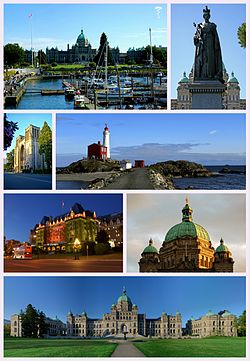
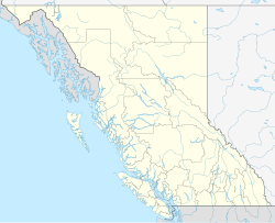
Victoria is 'n stad in die weste van Kanada. Dit is die hoofstad van die provinsie Brits-Columbië. Die stad lê in die uiterste suidooste van die Vancouver-eiland. Met 'n veerboot kan mens in 90 minute van hier na Vancouver op die vasteland vaar. Die stad is vernoem ná die Britse koningin Victoria, wat vanaf 1867 tot 1901 ook die koningin van Kanada was.
Inhoud
1 Geskiedenis
2 Demografie
3 Susterstede
4 Eksterne skakels
Geskiedenis |
Vancouver-eiland het in 1849 'n Britse kroonkolonie geword. Victoria word daarna aangewys as die hoofstad van Brits-Columbië.
Die Statebondspele is vanaf 18 - 28 Augustus 1994 in Victoria aangebied.
Demografie |
In 2011 het Victoria 80 032 inwoners en die agglomerasie ongeveer 344 000 inwoners gehad. Volgens die aantal inwoners is Victoria heelwat kleiner as Vancouver wat ook in Brits-Columbië geleë is.
Die Victoria-area is in 13 streke verdeel. Vier hiervan is deel van Groter Victoria:
- Victoria
- Saanich
- Esquimalt
- Oak-baai
Drie streke vorm die Saanich-skiereiland:
- Sidney
- Sentraal-Saanich
- Noord-Saanich
Die res is deel van die Westelike Gemeenskappe (Western Communities):
- Colwood
- Langford
- View Royal
- Metchosin
- Sooke
- Highlands
Susterstede |
Victoria het vyf susterstede, naamlik:
 Chabarofsk, Rusland
 Napier, Nieu-Seeland
 Morioka, Japan
 Sutsjou, Volksrepubliek China
 Anacortes, Verenigde State
Eksterne skakels |
| Wikimedia Commons bevat media in verband met Victoria, British Columbia. |
- Victoria se webtuiste
Hoofstede van Kanada | ||||
|---|---|---|---|---|
| ||||
Kategorieë:
- Hoofstede in Kanada
- Kusstede
- Nedersettings in Brits-Columbië
(window.RLQ=window.RLQ||[]).push(function()mw.config.set("wgPageParseReport":"limitreport":"cputime":"0.264","walltime":"0.371","ppvisitednodes":"value":2286,"limit":1000000,"ppgeneratednodes":"value":0,"limit":1500000,"postexpandincludesize":"value":35498,"limit":2097152,"templateargumentsize":"value":5071,"limit":2097152,"expansiondepth":"value":15,"limit":40,"expensivefunctioncount":"value":1,"limit":500,"unstrip-depth":"value":0,"limit":20,"unstrip-size":"value":0,"limit":5000000,"entityaccesscount":"value":1,"limit":400,"timingprofile":["100.00% 297.046 1 -total"," 54.90% 163.072 1 Sjabloon:Inligtingskas_Nedersetting"," 51.73% 153.658 1 Sjabloon:Inligtingskas_Nedersetting-en"," 25.28% 75.096 1 Sjabloon:Geobox_coor"," 24.05% 71.452 1 Sjabloon:Coord"," 15.85% 47.085 1 Sjabloon:Normdata"," 13.22% 39.259 1 Sjabloon:Commonskat"," 11.32% 33.628 5 Sjabloon:Vlagikoon"," 7.78% 23.122 1 Sjabloon:Commons"," 6.66% 19.772 1 Sjabloon:Sister_project"],"scribunto":"limitreport-timeusage":"value":"0.049","limit":"10.000","limitreport-memusage":"value":1480136,"limit":52428800,"cachereport":"origin":"mw1294","timestamp":"20190312081055","ttl":2592000,"transientcontent":false);mw.config.set("wgBackendResponseTime":124,"wgHostname":"mw1239"););


